
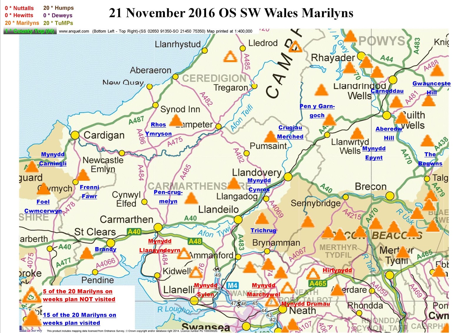
Trip plan
After completing all of the English & Welsh Nuttalls on Arenig Fach earlier this month there is no time for empty feelings or loss of purpose. Still plenty of hills left to climb and whilst my next focus will be on the Munros (202 of which are also Marilyns) the long term objective is to visit all 1556 GB Marilyns. To that end this trip gives the excuse to return to SW Wales and target the 20 outstanding Marilyns un-climbed south of the line between Builth Wales and the northern boundary of Pembrokeshre. This includes all 41Marilyns in Area 32 the 4 of the most southerly Marilyns of Area 31B and all but the 5 most Northerly in Area 31C, making a total 54. Most of these where visited as part of the Brecon Beacons Nuttalls plus two dedicated trips at the beginning of this year concentrating purely on the remaining Non-Nuttall Brecon Beacons Marilyns along with the more easterly Marilyns east of and near Cardiff.
20 Marilyns, 5 walking days available 4 a day. Only problem being the weather and the first storm of the year in the guise of "Storm Angus" timed to arrive on the first walking day of this trip.
Whilst I do not like to use bad weather as an excuse there are times when common sense prevails and I decided to dealy the trip by one day and drive when the weather was doing its worst.
Still intent on completing all 20 Marilyns the plan was changed to incude 5 Marilyns on each of the 4 remaining days.
As it turned out I could only manage four on each of the first three days and three on the fourth and final day. So 15 completed in all leaving five (marked in red below) around Swansea & Neath left to do.
Day 01 Tuesday 22 November 2016
Walk Statistics
20 Marilyns, 5 walking days available 4 a day. Only problem being the weather and the first storm of the year in the guise of "Storm Angus" timed to arrive on the first walking day of this trip.
Whilst I do not like to use bad weather as an excuse there are times when common sense prevails and I decided to dealy the trip by one day and drive when the weather was doing its worst.
Still intent on completing all 20 Marilyns the plan was changed to incude 5 Marilyns on each of the 4 remaining days.
As it turned out I could only manage four on each of the first three days and three on the fourth and final day. So 15 completed in all leaving five (marked in red below) around Swansea & Neath left to do.
 |
| O/S SW Wales Marilyns |
 |
| O/S SW Wales Marilyns walk summary |
Walk Date - 23 November 2016
Walkers - Steve Smith
Accommodation - Fforest Fields Caravan/Camping Site, Hundred House
Start Point - Various (see maps below)
Finish Point - Various (see maps below)
Total Duration - 4hrs 15mins
Overall Average pace - 2.35mph
Total Distance Walked - 9.97 miles
Total Height Ascended - 734.15metres
Peaks visited
Marilyns (158W - 1556E,W&S)
Gwaunceste Hill (107W - 275E,W&S)
Carneddau (108W - 276E,W&S)
The Begwns (109W - 277E,W&S)
Pen y Garn-goch (110W - 278E,W&S)
Deweys (241W - 421E&W)
Gwaunceste Hill (65W - 121E&W)
HuMPs (364W - 2975EW&S)
E,W&S:England,Wales & Scotland
Walkers - Steve Smith
Accommodation - Fforest Fields Caravan/Camping Site, Hundred House
Start Point - Various (see maps below)
Finish Point - Various (see maps below)
Total Duration - 4hrs 15mins
Overall Average pace - 2.35mph
Total Distance Walked - 9.97 miles
Total Height Ascended - 734.15metres
Peaks visited
Marilyns (158W - 1556E,W&S)
Gwaunceste Hill (107W - 275E,W&S)
Carneddau (108W - 276E,W&S)
The Begwns (109W - 277E,W&S)
Pen y Garn-goch (110W - 278E,W&S)
Deweys (241W - 421E&W)
Gwaunceste Hill (65W - 121E&W)
HuMPs (364W - 2975EW&S)
Gwaunceste Hill (128W - 363E,W&S)
Carneddau (129W - 364E,W&S)
The Begwns (130W - 365E,W&S)
Pen y Garn-goch (131W - 366E,W&S)
Historic County Tops (413E - 93E,W&S)
NONE
Carneddau (129W - 364E,W&S)
The Begwns (130W - 365E,W&S)
Pen y Garn-goch (131W - 366E,W&S)
Historic County Tops (413E - 93E,W&S)
NONE
W: Wales.
E,W: England & Wales. E,W&S:England,Wales & Scotland
Gwaunceste Hill
3.75 miles, 254.08m ascent, Start Time 09:56am, Finish Time 11:20am, 1 hours 24 minutes, 2.68 mph
Straight forward there and back route along farm track past derlict farm building then on to SSSI. Due to SSSI status stayed on track all the way to summit rather than direct route across heather. Convenient place to park near field entrance opposite Rhewey Farm (SO 14739 57460).
Carneddau
1.85 miles, 187.46m ascent, Start Time 11:56am, Finish Time 12:45pm, 0 hours 49 minutes, 2.27 mph
Approached from shorter NW route parking at SO 06050 55943. The regular spot on corner at disused quarry entrance was occupied. No path shown on map but path on ground to final ascent between 410m contour rings. From there direct ascent to summit (small pile of stones). Return by same route.
The Begwyns
1.07 miles, 70.29m ascent, Start Time 13:34pm, Finish Time 14:24pm, 0 hours 50 minutes, 1.28 mph
Parked on roadside ESE of The Roundabout SO 16169 44188. Went to trig first then walked all the way round outside of The Roundabout. Went inside through gate and stood on highest point occupied by a semi- mature tree. Visited alternative high point a few metres north. Easy bag less than half mile total.
Pen y Garn-goch
3.30 miles, 222.32m ascent, Start Time 15:27pm, Finish Time 16:39pm, 1 hours 12 minutes, 2.75 mph
Parked in forest road entrance SN 89096 50399. Only suitable spot between Bwlchmawr Farm and Pistyll gwynedd Farm.
Took the advice on from earlier posts and followed forestry road and all it's switchbacks almost all the way to the summit. The road ends just south of the summit but a track loops round the east and back along the north side.
A lot of clearance has taken place but was never tempted to venture in to the trees. It was impenetrable.
Day 02 Wednesday 23 November 2016
 |
| Gwaunceste Hill summit and trig pillar. Snow on Radnor Forest Nuttalls to the north
Click on photograph to view slide-show
|
 |
GPX can be downloaded from www.shareyouradventure.com |
Straight forward there and back route along farm track past derlict farm building then on to SSSI. Due to SSSI status stayed on track all the way to summit rather than direct route across heather. Convenient place to park near field entrance opposite Rhewey Farm (SO 14739 57460).
 |
| Carneddau summit marked by a few stones on a large flat grassy summit
Click on photograph to view slide-show
|
 |
GPX can be downloaded from www.shareyouradventure.com |
Approached from shorter NW route parking at SO 06050 55943. The regular spot on corner at disused quarry entrance was occupied. No path shown on map but path on ground to final ascent between 410m contour rings. From there direct ascent to summit (small pile of stones). Return by same route.
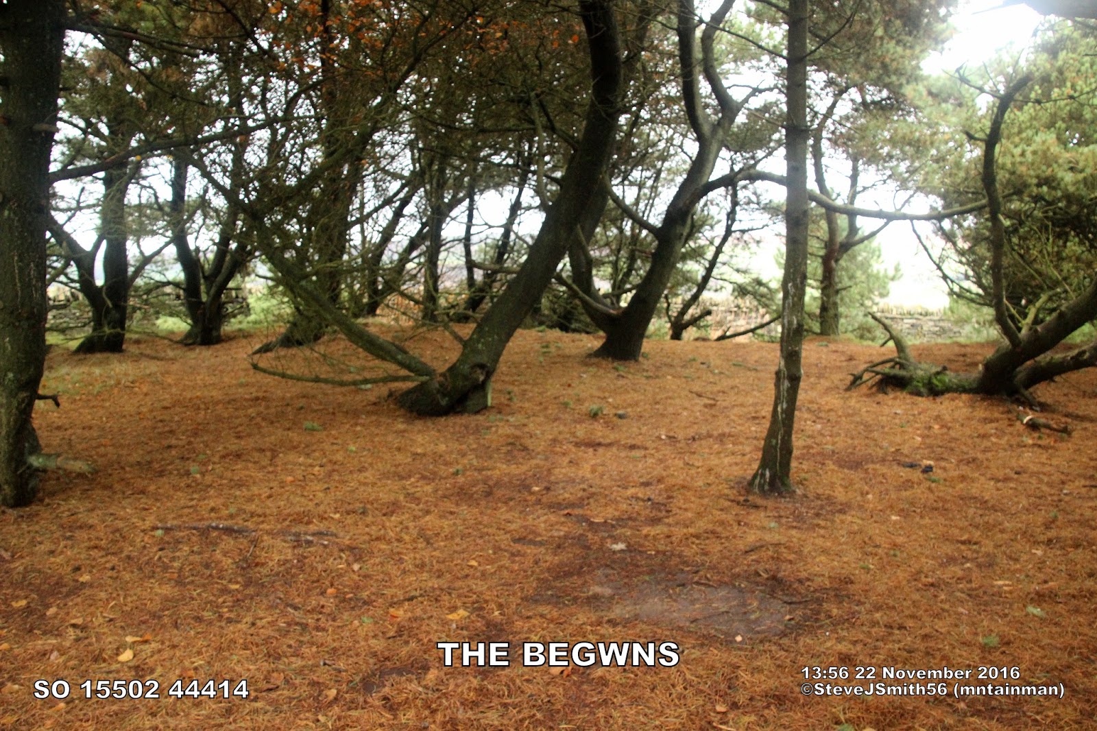 |
The Begwns summit within The Roundabout boundary
Click on photograph to view slide-show
|
 |
GPX can be downloaded from www.shareyouradventure.com |
Parked on roadside ESE of The Roundabout SO 16169 44188. Went to trig first then walked all the way round outside of The Roundabout. Went inside through gate and stood on highest point occupied by a semi- mature tree. Visited alternative high point a few metres north. Easy bag less than half mile total.
 |
| Pen y Garn-goch summit is centre cairn, trig point beyond cairns to the right
Click on photograph to view slide-show
|
 |
GPX can be downloaded from www.shareyouradventure.com |
Parked in forest road entrance SN 89096 50399. Only suitable spot between Bwlchmawr Farm and Pistyll gwynedd Farm.
Took the advice on from earlier posts and followed forestry road and all it's switchbacks almost all the way to the summit. The road ends just south of the summit but a track loops round the east and back along the north side.
A lot of clearance has taken place but was never tempted to venture in to the trees. It was impenetrable.
Walk Statistics
2.74 miles, 296.43m ascent, Start Time 10:05am, Finish Time 11:14am, 1 hours 09 minutes, 2.38 mph
Had planned a leisurely 5 mile route from the NE starting from overnight base at Fforest Fields Caravan/Camping Site near Hundred House, but the overnight rain had been replaced by fog down to about 300m, so decided on shorter route starting to the SE (SO 06892 50066)Light drizzle on the summit but periodic views of the Wye Valley on descent as broke through cloud. Straight forward ascent up farm track to summit rim then footpath through grass to trig and summit. Caught a glimpse of ancient cairn to the east and visited in case was higher.
Mynydd Eppynt [Mynydd Epynt]
0.51 miles, 39.48m ascent, Start Time 11:51am, Finish Time 12:03pm, 0 hours 12 minutes, 2.55 mph
Really thick fog on summit. Parked in car park at viewing point and quickly nipped up track to summit, ¼ mile each way. Looks like car park is start of 2nd stage of Epynt Way and track is part of PROW http://www.epyntway.org/sites/default/files/Map_10.pdf
Crugiau Merched
1.89 miles, 242.49m ascent, Start Time 13:19pm, Finish Time 14:24pm, 1 hours 05 minutes, 1.74 mph
Parked outside gate entrance to Bwlch-y-rhiw chapel (SN 72982 46430) asked permission at house and granted. Ascended steep quad bike track up west side of Gogyrnant accessed via two gates to north and east of cottage. At top of steep descent track tends to continue south but needed to head SW towards summit. Track did re-appear occasionally but mostly across heather. Visited tumulus and shelter first to the east then on to summit at large cairn near trig pillar. Returned by same route.
Mynydd Cynros
2.10 miles, 198.66m ascent, Start Time 15:14pm, Finish Time 16:09pm, 0 hours 55 minutes, 2.29 mph
Last of four Marilyns of the day. Parked at forestry car park and road entrance opposite Talley Abbey. Short walk up forest track before forking right up path with a single switchback that takes you to summit rim visible ahead. Rather than head straight over fence on to Open Access land turn left down track and right over stile following fence to summit over easier ground along boundary fence with sheep pasture. Gate at top gives access to Open Access land on left and near summit and trig. Returned along same route getting to van just on dusk.
Day 03 Thursday 22 November 2016
Walk Statistics
2.43 miles, 161.13m ascent, Start Time 09:49am, Finish Time 10:49am, 1 hours 00 minutes, 2.43 mph
Parked in lay by on A478 (SN 18908 35984)took side road to the south to pick up PROW bridleway and followed to WNW tip of Open Acccess land then followed path beyond fence line to summit. Drawn to trig slightly higher ground just to west. Returned along same route.
Mynydd Carningli
1.16 miles, 174.87m ascent, Start Time 11:29am, Finish Time 12:27pm, 0 hours 58 minutes, 1.20 mph
Parked in car park just ½ mile east of summit. Easy grass path to follow to base of steep rock ascent to summit, combination of natural and man placed steps. Very difficult to determine highest of 3 tors. Plumped for first one reached to the NE. Could have gone to spec savers should have checked survey comments on hill-bagging first. Visited all 3 just to be sure and ended up slipping on damp rocks picking up a couple of extra bruises, reminder that care needs to be taken.
Foel Cwmcerwyn
3.65 miles, 156.45m ascent, Start Time 13:10pm, Finish Time 14:44pm, 1 hours 34 minutes, 2.33 mph
Easy parking at Bwlch-gwynt (SN 07521 32187). Followed bridleway west to harvested plantation corner at Pen Cisty then follow distinct path worn through boggy ground to summit. Cold and crisp at summit but lovely clear views all round. Stood on tumulus to NE as looked as high before going to trig. Returned along same route.
Brandy Hill
0.27 miles, 4.94m ascent, Start Time 15:48pm, Finish Time 16:04pm, 0 hours 16 minutes, 1.01 mph
Long drive if doing as part of a multi hill day but a short walk from reservoir entrance up west side of reservoir. Thought access from road was going to be difficult, apparently there is a gate a little further on can not verify as went through hole in hedge kindly cut by previous visitor. No crops in field so wandered to middle to take photo and stand on what looked to me like natural higher ground, but probably is not.
Day 04 Friday 25 November 2016
Rhos Ymryson
1.25 miles, 52.21m ascent, Start Time 11:28am, Finish Time 12:08pm, 0 hours 40 minutes, 1.88 mph
Massive lay by opposite gated field entrance on B4338 (SN 45949 50699) giving access to hill top reservoir. Highest point is clearly top of reservoir within locked compound but also obviously man made. Walked all round perimeter fence where looks like highest natural point is on southern boundary near SE corner of reservoir.
Pen-crug-melyn
0.44 miles, 23.92m ascent, Start Time 13:28pm, Finish Time 13:50pm, 0 hours 22 minutes, 1.20 mph
Adequate off road parking for two cars near gated entrance to PROW and access to Pen-crug-melyn (SN 50143 28245). Barbed wire fence on southern boundary but trig point on Tumulus and highest point can be approached up steep bank from the east.
Trichrug
2.16 miles, 145m ascent, Start Time 14:55pm, Finish Time 15:49pm, 0 hours 54 minutes, 2.40 mph
Off road parking on corner of road and public access track (SN 69482 21589). Continued north on track past Blaen-Llynnant to to 336m spot height then over style and leave track to the right up north side of wall to summit. Highest point is this side of wall though had to climb over brand new barb wire fence to stand next to trig point. Returned by the same route.
Walk Date - 22 October 2016
Walkers - Steve Smith
Accommodation - Fforest Fields Caravan/Camping Site, Hundred House
Start Point - Various (see maps below)
Finish Point - Various (see maps below)
Total Duration - 3hrs 21mins
Overall Average pace - 2.16mph
Total Distance Walked - 7.24 miles
Total Height Ascended - 777.06metres
Peaks visited
Marilyns (158W - 1556E,W&S)
Aberedw Hill (111W - 279E,W&S)
Mynydd Epynt [Mynydd Eppynt] (112W - 280E,W&S)
Crugiau Merched (113W - 281E,W&S)
Mynydd Cynros (114W - 282E,W&S)
Deweys (241W - 421E&W)
NONE
HuMPs (364W - 2975EW&S)
E,W&S:England,Wales & Scotland
Aberedw HillWalkers - Steve Smith
Accommodation - Fforest Fields Caravan/Camping Site, Hundred House
Start Point - Various (see maps below)
Finish Point - Various (see maps below)
Total Duration - 3hrs 21mins
Overall Average pace - 2.16mph
Total Distance Walked - 7.24 miles
Total Height Ascended - 777.06metres
Peaks visited
Marilyns (158W - 1556E,W&S)
Aberedw Hill (111W - 279E,W&S)
Mynydd Epynt [Mynydd Eppynt] (112W - 280E,W&S)
Crugiau Merched (113W - 281E,W&S)
Mynydd Cynros (114W - 282E,W&S)
Deweys (241W - 421E&W)
NONE
HuMPs (364W - 2975EW&S)
Aberedw Hill (132W - 367E,W&S)
Mynydd Epynt [Mynydd Eppynt] (133W - 368E,W&S)
Crugiau Merched (134W - 369E,W&S)
Mynydd Cynros (135W - 370E,W&S)
Historic County Tops (413E - 93E,W&S)
NONE
Mynydd Epynt [Mynydd Eppynt] (133W - 368E,W&S)
Crugiau Merched (134W - 369E,W&S)
Mynydd Cynros (135W - 370E,W&S)
Historic County Tops (413E - 93E,W&S)
NONE
W: Wales.
E,W: England & Wales. E,W&S:England,Wales & Scotland
 |
Aberedw Hill summit ground just east of trig pillar
Click on photograph to view slide-show
|
 |
GPX can be downloaded from www.shareyouradventure.com |
Had planned a leisurely 5 mile route from the NE starting from overnight base at Fforest Fields Caravan/Camping Site near Hundred House, but the overnight rain had been replaced by fog down to about 300m, so decided on shorter route starting to the SE (SO 06892 50066)Light drizzle on the summit but periodic views of the Wye Valley on descent as broke through cloud. Straight forward ascent up farm track to summit rim then footpath through grass to trig and summit. Caught a glimpse of ancient cairn to the east and visited in case was higher.
 |
| Mynydd Epynt high ground NW of track concrete pillar. Summit marked by concrete pillar just visible amongst grass
Click on photograph to view slide-show
|
 |
GPX can be downloaded from www.shareyouradventure.com |
Really thick fog on summit. Parked in car park at viewing point and quickly nipped up track to summit, ¼ mile each way. Looks like car park is start of 2nd stage of Epynt Way and track is part of PROW http://www.epyntway.org/sites/default/files/Map_10.pdf
 |
| Summit cairn on Crugiau Merched. Cairn beyond is slightly lower Click on photograph to view slide-show |
 |
GPX can be downloaded from www.shareyouradventure.com |
Parked outside gate entrance to Bwlch-y-rhiw chapel (SN 72982 46430) asked permission at house and granted. Ascended steep quad bike track up west side of Gogyrnant accessed via two gates to north and east of cottage. At top of steep descent track tends to continue south but needed to head SW towards summit. Track did re-appear occasionally but mostly across heather. Visited tumulus and shelter first to the east then on to summit at large cairn near trig pillar. Returned by same route.
 |
Mynydd Cynros trig and summit
Click on photograph to view slide-show
|
 |
GPX can be downloaded from www.shareyouradventure.com |
Last of four Marilyns of the day. Parked at forestry car park and road entrance opposite Talley Abbey. Short walk up forest track before forking right up path with a single switchback that takes you to summit rim visible ahead. Rather than head straight over fence on to Open Access land turn left down track and right over stile following fence to summit over easier ground along boundary fence with sheep pasture. Gate at top gives access to Open Access land on left and near summit and trig. Returned along same route getting to van just on dusk.
Walk Statistics
Walk Date - 24 October 2016
Walkers - Steve Smith
Accommodation - Argoed Meadow campsite, Cenarth
Start Point - Various (see maps below)
Finish Point - Various (see maps below)
Total Duration - 3hrs 48mins
Overall Average pace - 1.98mph
Total Distance Walked - 7.51 miles
Total Height Ascended - 497.39metres
Peaks visited
Marilyns (158W - 1556E,W&S)
Frenni Fawr (115W - 283E,W&S)
Mynydd Carningli (116W - 284E,W&S)
Foel Cwmcerwyn (117W - 285E,W&S)
Brandy Hill (118W - 286E,W&S)
Deweys (241W - 421E&W)
Foel Cwmcerwyn (66W - 122E&W)
HuMPs (364W - 2975EW&S)
E,W&S:England,Wales & Scotland
Frenni Fawr
Walkers - Steve Smith
Accommodation - Argoed Meadow campsite, Cenarth
Start Point - Various (see maps below)
Finish Point - Various (see maps below)
Total Duration - 3hrs 48mins
Overall Average pace - 1.98mph
Total Distance Walked - 7.51 miles
Total Height Ascended - 497.39metres
Peaks visited
Marilyns (158W - 1556E,W&S)
Frenni Fawr (115W - 283E,W&S)
Mynydd Carningli (116W - 284E,W&S)
Foel Cwmcerwyn (117W - 285E,W&S)
Brandy Hill (118W - 286E,W&S)
Deweys (241W - 421E&W)
Foel Cwmcerwyn (66W - 122E&W)
HuMPs (364W - 2975EW&S)
Frenni Fawr (136W - 371E,W&S)
Mynydd Carningli (137W - 372E,W&S)
Foel Cwmcerwyn (138W - 373E,W&S)
Brandy Hill (139W - 374E,W&S)
Historic County Tops (13W - 93E,W&S)
Foel Cwmcerwyn (11W - 54E,W&S)
Mynydd Carningli (137W - 372E,W&S)
Foel Cwmcerwyn (138W - 373E,W&S)
Brandy Hill (139W - 374E,W&S)
Historic County Tops (13W - 93E,W&S)
Foel Cwmcerwyn (11W - 54E,W&S)
W: Wales.
E,W: England & Wales. E,W&S:England,Wales & Scotland
 |
| Frenni Fawr trig and summit looking towards Preseli Hills
Click on photograph to view slide-show
|
 |
GPX can be downloaded from www.shareyouradventure.com |
Parked in lay by on A478 (SN 18908 35984)took side road to the south to pick up PROW bridleway and followed to WNW tip of Open Acccess land then followed path beyond fence line to summit. Drawn to trig slightly higher ground just to west. Returned along same route.
 |
| Highest point on Mynydd Carningli is the most North Easterly of the 3 tors
Click on photograph to view slide-show
|
 |
GPX can be downloaded from www.shareyouradventure.com |
Parked in car park just ½ mile east of summit. Easy grass path to follow to base of steep rock ascent to summit, combination of natural and man placed steps. Very difficult to determine highest of 3 tors. Plumped for first one reached to the NE. Could have gone to spec savers should have checked survey comments on hill-bagging first. Visited all 3 just to be sure and ended up slipping on damp rocks picking up a couple of extra bruises, reminder that care needs to be taken.
 |
| Foel Cwmcerwyn trig pillar built on firm foundations, stood on high point just behind trig with lower ancient cairn 25m NE
Click on photograph to view slide-show
|
 |
GPX can be downloaded from www.shareyouradventure.com |
Easy parking at Bwlch-gwynt (SN 07521 32187). Followed bridleway west to harvested plantation corner at Pen Cisty then follow distinct path worn through boggy ground to summit. Cold and crisp at summit but lovely clear views all round. Stood on tumulus to NE as looked as high before going to trig. Returned along same route.
 |
| Brandy Hill trig Pillar near field boundary on west side of reservoir compound
Click on photograph to view slide-show
|
 |
GPX can be downloaded from www.shareyouradventure.com |
Long drive if doing as part of a multi hill day but a short walk from reservoir entrance up west side of reservoir. Thought access from road was going to be difficult, apparently there is a gate a little further on can not verify as went through hole in hedge kindly cut by previous visitor. No crops in field so wandered to middle to take photo and stand on what looked to me like natural higher ground, but probably is not.
Walk Statistics
Walk Date - 23 November 2016
Walkers - Steve Smith
Accommodation - Argoed Meadow campsite, Cenarth
Start Point - Various (see maps below)
Finish Point - Various (see maps below)
Total Duration - 1hrs 56mins
Overall Average pace - 1.99mph
Total Distance Walked - 3.85 miles
Total Height Ascended - 221.28metres
Peaks visited
Marilyns (158W - 1556E,W&S)
Rhos Ymryson (119W - 287E,W&S)
Pen-crug-melyn (120W - 288E,W&S)
Trichrug (121W - 289E,W&S)
Deweys (241W - 421E&W)
NONE
HuMPs (364W - 2975EW&S)
E,W&S:England,Wales & Scotland
Walkers - Steve Smith
Accommodation - Argoed Meadow campsite, Cenarth
Start Point - Various (see maps below)
Finish Point - Various (see maps below)
Total Duration - 1hrs 56mins
Overall Average pace - 1.99mph
Total Distance Walked - 3.85 miles
Total Height Ascended - 221.28metres
Peaks visited
Marilyns (158W - 1556E,W&S)
Rhos Ymryson (119W - 287E,W&S)
Pen-crug-melyn (120W - 288E,W&S)
Trichrug (121W - 289E,W&S)
Deweys (241W - 421E&W)
NONE
HuMPs (364W - 2975EW&S)
Rhos Ymryson (140W - 375E,W&S)
Pen-crug-melyn (141W - 376E,W&S)
Trichrug (142W - 377E,W&S)
Historic County Tops (413E - 93E,W&S)
NONE
Pen-crug-melyn (141W - 376E,W&S)
Trichrug (142W - 377E,W&S)
Historic County Tops (413E - 93E,W&S)
NONE
W: Wales.
E,W: England & Wales. E,W&S:England,Wales & Scotland
Rhos Ymryson
 |
| Rhos Ymryson natural summit on/near reservoir boundary fence. Maybe slightly higher within compound but likely to be man made
Click on photograph to view slide-show
|
 |
GPX can be downloaded from www.shareyouradventure.com |
Massive lay by opposite gated field entrance on B4338 (SN 45949 50699) giving access to hill top reservoir. Highest point is clearly top of reservoir within locked compound but also obviously man made. Walked all round perimeter fence where looks like highest natural point is on southern boundary near SE corner of reservoir.
 |
| Pen-crug-melyn trig pillar from the south. Summit is just in front to the right of pillar
Click on photograph to view slide-show
|
 |
GPX can be downloaded from www.shareyouradventure.com |
Adequate off road parking for two cars near gated entrance to PROW and access to Pen-crug-melyn (SN 50143 28245). Barbed wire fence on southern boundary but trig point on Tumulus and highest point can be approached up steep bank from the east.
 |
| Trichrug summit on north side of wall. Trig pillar slightly lower on other side of wall over a brand new barb wire fence
Click on photograph to view slide-show
|
 |
GPX can be downloaded from www.shareyouradventure.com |
Off road parking on corner of road and public access track (SN 69482 21589). Continued north on track past Blaen-Llynnant to to 336m spot height then over style and leave track to the right up north side of wall to summit. Highest point is this side of wall though had to climb over brand new barb wire fence to stand next to trig point. Returned by the same route.