
Walk summary
Today actually went as planned, not following the plan set in Suffolk but the revised plan quickly prepared last night based on the new trip strategy established yesterday to complete all but 1 of the 13 Marilyns of Area 38B:West Gloucestershire, Hereford & Worcester bagging each Marilyn by driving as close to the summit and walking the minimum distance. Worcestershire Beacon would be the missing hill, saving that for when I return with Gina as part of our quest to visit all 63 Historic County Tops of England & Wales.
This had the benefit of increasing my Marilyn count whilst at the same time building up hill strength and fitness with short walks involving ascent. Yesterdays 5 short walks bagged 5 of the 12 Marilyns, ranging from just getting out of the van at Ruardean Hill through to 2.58miles for Seager Hill and overall still involved walking 7.1 miles with 438m of ascent , similar to what has been achieved on some of the easier Nuttall routes, But important for early back injury rehabilitation - without the need to take a backpack.
Today's plan would still bag 5 Marilyns, will be over 4 walks, increase the daily distance/ascent and crucially increase the distance of the longest walk, but again without the need to carry a backpack.
Today also marked a significant milestone in as much as Burton Hill would be my 150th Marilyn climbed in England, Wales & Scotland. 25% of the way towards the Marilyn Hall of Fame target of 600. The very first Marilyn (before I had even heard of Marilyns) was Pen-y-gent back on 03 October 2008. That's 7 years 13 days ago. At that rate it will be 21 years and 39 days to complete 600 taking me to just past my 80th birthday. Well I am hoping to achieve 600 well before then. But before setting any arbitrary targets (My 65th birthday) let's see how long it takes me do the next 150.
Peaks visited
Nuttalls (254E - 443E&W)
NONE
Hewitts (179E - 316E&W)
NONE
Marilyns (175E - 1550E,W&S)
Hegdon Hill (77E - 149E,W&S)
Burton Hill (78E - 150E,W&S)
High Vinnalls (79E - 151E,W&S)
Wapley Hill (80E - 152E,W&S)
Shobdon Hill (81E - 153E,W&S)
Deweys (181E - 422EW&S)
NONE
HuMPs (444E - 2975EW&S)
Other walks on this trip
2015
October
15th West Gloucestershire and South Herefordshire Marilyns
16th North Herefordshire Marilyns
17th Hergest Ridge & Bradnor Hill + Bredon Hill
Walkers - Steve Smith
Accommodation - Lucksall Caravan and Camping Park
Start Point - Various. See maps below
Finish Point - Various. See maps below
Total Duration - 4hrs 35mins
Overall Average pace - 2.48mph
Total Distance Walked - 11.38 miles
Total Height Ascended - 767.93 metres
Hegdon Hill
0.23 miles, 3.86m ascent.
First hill/Marilyn of the day and a fairly easy one at that. Rather than walking over 3 miles as planned starting at Pencombe I drove more or less to the top, parked at entrance to Little Hegdon and walked along the road, through an open gate and along the field boundary to what is the highest point. My very first drive up bag without a guilty conscience. Well what is the point of walking 3.38 miles just to say you have walked along the Three Rivers Ride.
Burton Hill
1.62 miles, 172.66m ascent.
Slightly longer walk this time but still less than half the planned route. Convenient parking spot off road next to a gate with foot path entrance across field to Shoals bank brought me to an access road to a water pumping station then following a new unmapped forestry road close to the summit. Use of smartphone helped me locate the summit a few 10's of metres off to the right in undergrowth and then on to the trig point again with use of smartphone as this time marked tracks on map no longer exist on the ground.before returning to the van along the same route.
 |
| Wapley Hillfort inner ramparts and 329m spot height |
This had the benefit of increasing my Marilyn count whilst at the same time building up hill strength and fitness with short walks involving ascent. Yesterdays 5 short walks bagged 5 of the 12 Marilyns, ranging from just getting out of the van at Ruardean Hill through to 2.58miles for Seager Hill and overall still involved walking 7.1 miles with 438m of ascent , similar to what has been achieved on some of the easier Nuttall routes, But important for early back injury rehabilitation - without the need to take a backpack.
Today's plan would still bag 5 Marilyns, will be over 4 walks, increase the daily distance/ascent and crucially increase the distance of the longest walk, but again without the need to carry a backpack.
Today also marked a significant milestone in as much as Burton Hill would be my 150th Marilyn climbed in England, Wales & Scotland. 25% of the way towards the Marilyn Hall of Fame target of 600. The very first Marilyn (before I had even heard of Marilyns) was Pen-y-gent back on 03 October 2008. That's 7 years 13 days ago. At that rate it will be 21 years and 39 days to complete 600 taking me to just past my 80th birthday. Well I am hoping to achieve 600 well before then. But before setting any arbitrary targets (My 65th birthday) let's see how long it takes me do the next 150.
Peaks visited
Nuttalls (254E - 443E&W)
NONE
Hewitts (179E - 316E&W)
NONE
Marilyns (175E - 1550E,W&S)
Hegdon Hill (77E - 149E,W&S)
Burton Hill (78E - 150E,W&S)
High Vinnalls (79E - 151E,W&S)
Wapley Hill (80E - 152E,W&S)
Shobdon Hill (81E - 153E,W&S)
Deweys (181E - 422EW&S)
NONE
HuMPs (444E - 2975EW&S)
Hegdon Ridge (133E - 225E,W&S)
Burton Hill (134E - 226E,W&S)
High Vinnalls (135E - 227E,W&S)
Wapley Hill (136E - 228E,W&S)
Shobdon Hill (137E - 229E,W&S)
Historic County Tops (49E - 93E,W&S)
NONE
Burton Hill (134E - 226E,W&S)
High Vinnalls (135E - 227E,W&S)
Wapley Hill (136E - 228E,W&S)
Shobdon Hill (137E - 229E,W&S)
Historic County Tops (49E - 93E,W&S)
NONE
W: Wales.
E,W&S:England,Wales & ScotlandOther walks on this trip
2015
October
15th West Gloucestershire and South Herefordshire Marilyns
16th North Herefordshire Marilyns
17th Hergest Ridge & Bradnor Hill + Bredon Hill
Walk Statistics
Walk Date - 16 October 2015Walkers - Steve Smith
Accommodation - Lucksall Caravan and Camping Park
Start Point - Various. See maps below
Finish Point - Various. See maps below
Total Duration - 4hrs 35mins
Overall Average pace - 2.48mph
Total Distance Walked - 11.38 miles
Total Height Ascended - 767.93 metres
Hegdon Hill
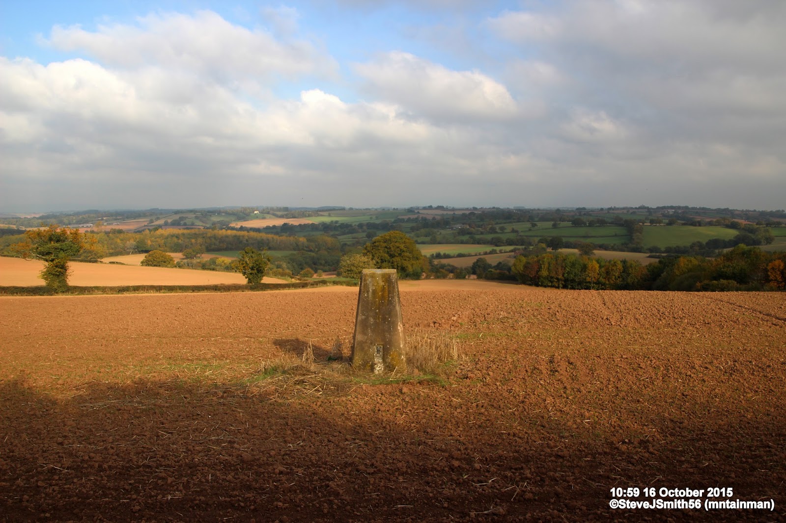 |
| Looking NE from Hegdon Hill high point
Click on photograph to view slide-show
|
 |
| GPX can be downloaded from www.shareyouradventure.com |
First hill/Marilyn of the day and a fairly easy one at that. Rather than walking over 3 miles as planned starting at Pencombe I drove more or less to the top, parked at entrance to Little Hegdon and walked along the road, through an open gate and along the field boundary to what is the highest point. My very first drive up bag without a guilty conscience. Well what is the point of walking 3.38 miles just to say you have walked along the Three Rivers Ride.
 |
| Looking down at walk start point from Shoals Bank.
Click on photograph to view slide-show
|
 |
| GPX can be downloaded from www.shareyouradventure.com |
Slightly longer walk this time but still less than half the planned route. Convenient parking spot off road next to a gate with foot path entrance across field to Shoals bank brought me to an access road to a water pumping station then following a new unmapped forestry road close to the summit. Use of smartphone helped me locate the summit a few 10's of metres off to the right in undergrowth and then on to the trig point again with use of smartphone as this time marked tracks on map no longer exist on the ground.before returning to the van along the same route.
High Vinnalls
2.36 miles, 148.55m ascent.
Just a short ¾ mile walk from Mortimer Forest Vinnalls car park to the summit marked by a bench. I could have returned the same way but chose to continue along the ridge enjoying views to the east. In spite of what I say about taking the easiest route I still like to explore the chance to see more and complete a circular route if possible.
Wapley Hill & Shobdon Hill
7.17 miles, 442.86m ascent.
By the time I found suitable parking at Wapley Hillfort car park it was getting fairly late in the day. This was one of the original planned routes and involved a circuitous 6 mile route. The time was just after 4pm which at 2 mph would take me about 2 hours 20mins. However planned routes do tend to be a bit shorter due to them being straighter on the map than the actual ground covered so I chose to go up Wapley Hill first meaning that I would be returning from Shobdon Hill along the road by about 6pm rather than hacking through undergrowth towards Wapley Hill.
Turned out this was the correct decision. I did manage to stay on the ridge along the Herfordshire/Mortimer Trail between Wapley & Shobdon Hill though it was easy to miss the over grown path to the right by following the forest track left at Lanes Wood. The ascent up, as was the sloping path across the path along the top ridge of Byton Common would also have been difficult to track if it had been dark. Even so it took nearly 2 hours to reach Shobdon Hill, just after 6pm. This just left the trig point to find which happened to be on the descent route and get to Hill Barn before the light faded. I did manage this but the urgency now was to get back to the car park before dusk. I remembered seeing the sign stating it was open between dawn and dusk but I did not remember if there was a gate that could be locked. If it was I would have a lonely night in the campervan, but I would much sooner spend the night on Lucksall Caravan and Camping Park. Being in the van I would not miss a hot meal or even a good nights sleep but I would miss the pint in The Moon at Mordiford as well as a lovely hot shower before dinner.
I got to the van at 18:53 and yes I could have argued it was dusk but turned out there was not a gate anyway. I had managed 7.17 miles in 2hours 39mins at an average pace of 2.71mph. Quicker pace than I had planned and to be honest more tired than I had planned especially as earlier recoveries had been caused by training whilst fatigued. But importantly this time I had done more rehab giving me more residual strength. What I had to do now was not take on any more walks that would fatigue me to this extent without adequate rest and recovery.
 |
| Walk start point Mortimer Forest, Vinnalls car park.
Click on photograph to view slide-show
|
 |
| GPX can be downloaded from www.shareyouradventure.com |
Just a short ¾ mile walk from Mortimer Forest Vinnalls car park to the summit marked by a bench. I could have returned the same way but chose to continue along the ridge enjoying views to the east. In spite of what I say about taking the easiest route I still like to explore the chance to see more and complete a circular route if possible.
Wapley Hill & Shobdon Hill
 |
| O/S Warren House near top of Wapley Hill.
Click on photograph to view slide-show
|
 |
| GPX can be downloaded from www.shareyouradventure.com |
By the time I found suitable parking at Wapley Hillfort car park it was getting fairly late in the day. This was one of the original planned routes and involved a circuitous 6 mile route. The time was just after 4pm which at 2 mph would take me about 2 hours 20mins. However planned routes do tend to be a bit shorter due to them being straighter on the map than the actual ground covered so I chose to go up Wapley Hill first meaning that I would be returning from Shobdon Hill along the road by about 6pm rather than hacking through undergrowth towards Wapley Hill.
Turned out this was the correct decision. I did manage to stay on the ridge along the Herfordshire/Mortimer Trail between Wapley & Shobdon Hill though it was easy to miss the over grown path to the right by following the forest track left at Lanes Wood. The ascent up, as was the sloping path across the path along the top ridge of Byton Common would also have been difficult to track if it had been dark. Even so it took nearly 2 hours to reach Shobdon Hill, just after 6pm. This just left the trig point to find which happened to be on the descent route and get to Hill Barn before the light faded. I did manage this but the urgency now was to get back to the car park before dusk. I remembered seeing the sign stating it was open between dawn and dusk but I did not remember if there was a gate that could be locked. If it was I would have a lonely night in the campervan, but I would much sooner spend the night on Lucksall Caravan and Camping Park. Being in the van I would not miss a hot meal or even a good nights sleep but I would miss the pint in The Moon at Mordiford as well as a lovely hot shower before dinner.
I got to the van at 18:53 and yes I could have argued it was dusk but turned out there was not a gate anyway. I had managed 7.17 miles in 2hours 39mins at an average pace of 2.71mph. Quicker pace than I had planned and to be honest more tired than I had planned especially as earlier recoveries had been caused by training whilst fatigued. But importantly this time I had done more rehab giving me more residual strength. What I had to do now was not take on any more walks that would fatigue me to this extent without adequate rest and recovery.