
Walk summary
This final full day of trip leaves the last two Marilyns of Herfefordshire to complete, with Worcestershire Beacon remaining of area 38B to be visited on a later trip with Gina as part of our joint mission to climb all the Historic County Tops of England & Wales.
It seems reasonable therefore to consider the trip a most satisfying success. OK I did not walk the distances planned but instead of visiting only 5 Marilyns I managed 12 of the 13 Area 38B:West Gloucestershire, Hereford & Worcester Marilyns, with Bredon Hill in Worcestershire being picked off on the way home tomorrow a total of 13 Marilyns pushes the total for England to 84, just 4 away from the tantalising 50% mark of all the 176 Marilyns in England. Yet another milestone bringing in to focus the evolving objective to join the Marilyn Hall of Fame (MHoF) and visit 600 Marilyns in England, Wales & Scotland.
Most importantly, writing this one week after returning, I managed 4 consecutive days walking without any adverse physical effects. Making me realise completing any peak bagging list there are plenty of opportunities for physically challenging walks, so do not need to make less remote peaks harder by walking unnecessary distances. By adopting this approach it seems more reasonable to complete the remaining 450 Marilyns in about the same (hopefully smaller) time frame it took to complete the first 150. (7 years and 13 days)
Peaks visited
Nuttalls (254E - 443E&W)
NONE
Hewitts (179E - 316E&W)
NONE
Marilyns (175E - 1550E,W&S)
Hergest Ridge (82E - 154E,W&S)
Bradnor Hill (83E - 155E,W&S)
Bredon Hill (84E - 156E,W&S)
Deweys (181E - 422EW&S)
NONE
HuMPs (444E - 2975EW&S)
Other walks on this trip
2015
October
15th West Gloucestershire and South Herefordshire Marilyns
16th North Herefordshire Marilyns
17th Hergest Ridge & Bradnor Hill + Bredon Hill
Walkers - Steve Smith
Accommodation - Lucksall Caravan and Camping Park
Start Point - Various. See maps below
Finish Point - Various. See maps below
Total Duration - 3hrs 52mins
Overall Average pace - 2.64mph
Total Distance Walked - 10.19 miles
Total Height Ascended - 632.33 metres
Hergest Ridge
4.92 miles, 258.52m ascent.
First planned as an 8 mile figure 8 route starting in Kington, following yesterdays late finish on Wapley & Shobdon Hills I had already decided to split the route in to two as a morning and afternoon walk with a spot of lunch in between. It seems however that yesterday took more out of me than I thought as by the time I had got up in the morning, got myself ready and driven to Kington, it was already past 2pm. So much for a morning walk.
So the plan now was to do two up and back walks along the ascent route still based in Kington. I decided to go up Hergest Ridge first for no other reason than it was the furthest but was soon thinking whilst walking along the Offas Dyke path up Ridgebourne Road why I had not driven close to the summit. See cars parked at the end of the road near Haywood Farm convinced me this is what I should have done and decided to drive closer to Bradnor Hill because no matter how tired I felt, there was no way I was not going to get the last Herefordshire hill out of the way on this trip.
As it turned out the walk up the road loosened up my tired legs making the steady ascent up to the high point along Offas Dyke towards Whet Stone most enjoyable. passing some spruce trees and memorial bench to Nan Farrar I came across a circular pond which I used to change course leaving the path and heading for Hergest Ridge summit marked by a large pile of, what I assume, naturally placed stones.
From here it was a quick walk east to the trig point then return back Offas Dyke following contours. Returning to the parked cars I was reminded that this would have been the best place to have parked myself cutting the total walk down by over a mile. On returning to the van I warmed some soup up in the van for a late lunch then drove closer to Bradnor Hill parking near Kington Golf Club.
Bradnor Hill
1.98 miles, 102.56m ascent.
There is parking in the golf club car park, but thought it best not to assum it was OK and parked on open ground near the car park entrance.
Rather than head straight for the summit past the club house I followed to past the club shop and along the eastern golf course boundary. I stayed on this track as it changed from tarmac to hard core then just a grass track, no doubt used by greenkeepers all the way round to the 7th Tee.
As it was now gone 5pm in October there were not any golfers on the course so it was a matter of walking the length of the 7 fairway then turning right towards the 8th tee where just beyond I found a pile of stones hidden by fern.
After photos and logging I was able to find the most direct path back to the track and return to the clubhouse to complete the final Herefordshire Marilyn.
Bredon Hill
3.29 miles, 271.25m ascent.
As if bagging 12 Marilyns on this trip instead of the planned five was not enough I managed a final bonus by stopping off in Great Comberton on the way home to pick off this isolated Marilyn.
The quickly hatched plan was a circular (yes I still like to do them if I can) walk through Manor Farm and on to the summit via Stump of Oak. then return from the summits along footpaths to the west then down the north ridge back to Great Comberton.
On top of the hill is Kemerton Camp an Iron Age Fort. More obvious is Banbury Stone Tower built in the 18th century on the inner ramparts.
Heading up hill I was expecting the tower to be the highest point but after following the ramparts round to the tower the highest point is clearly visible about 30m to the north east. Again you are naturally attracted to the viewing stone as the high point but it is in fact about 5m north in some clumps of grass.
Checking the descent route on my smartphone, for the third time this trip, the screen went blank even though the battery indicator said 40% available. Without any other map I had no alternative than to return back along the ascent route which I could remember. Although I will have paper maps for my next Nuttall trip I really must sort out this phone problem to properly log routes walked.
 |
| Evening sun showing Autumn colours near Kington Golf Clubhouse |
It seems reasonable therefore to consider the trip a most satisfying success. OK I did not walk the distances planned but instead of visiting only 5 Marilyns I managed 12 of the 13 Area 38B:West Gloucestershire, Hereford & Worcester Marilyns, with Bredon Hill in Worcestershire being picked off on the way home tomorrow a total of 13 Marilyns pushes the total for England to 84, just 4 away from the tantalising 50% mark of all the 176 Marilyns in England. Yet another milestone bringing in to focus the evolving objective to join the Marilyn Hall of Fame (MHoF) and visit 600 Marilyns in England, Wales & Scotland.
Most importantly, writing this one week after returning, I managed 4 consecutive days walking without any adverse physical effects. Making me realise completing any peak bagging list there are plenty of opportunities for physically challenging walks, so do not need to make less remote peaks harder by walking unnecessary distances. By adopting this approach it seems more reasonable to complete the remaining 450 Marilyns in about the same (hopefully smaller) time frame it took to complete the first 150. (7 years and 13 days)
Peaks visited
Nuttalls (254E - 443E&W)
NONE
Hewitts (179E - 316E&W)
NONE
Marilyns (175E - 1550E,W&S)
Hergest Ridge (82E - 154E,W&S)
Bradnor Hill (83E - 155E,W&S)
Bredon Hill (84E - 156E,W&S)
Deweys (181E - 422EW&S)
NONE
HuMPs (444E - 2975EW&S)
Hergest Ridge (138E - 230E,W&S)
Bradnor Hill (139E - 231E,W&S)
Bredon Hill (140E - 232E,W&S)
Historic County Tops (49E - 93E,W&S)
NONE
Bradnor Hill (139E - 231E,W&S)
Bredon Hill (140E - 232E,W&S)
Historic County Tops (49E - 93E,W&S)
NONE
W: Wales.
E,W&S:England,Wales & ScotlandOther walks on this trip
2015
October
15th West Gloucestershire and South Herefordshire Marilyns
16th North Herefordshire Marilyns
17th Hergest Ridge & Bradnor Hill + Bredon Hill
Walk Statistics
Walk Date - 17 October 2015 (18 October 2015-Bredon Hill)Walkers - Steve Smith
Accommodation - Lucksall Caravan and Camping Park
Start Point - Various. See maps below
Finish Point - Various. See maps below
Total Duration - 3hrs 52mins
Overall Average pace - 2.64mph
Total Distance Walked - 10.19 miles
Total Height Ascended - 632.33 metres
Hergest Ridge
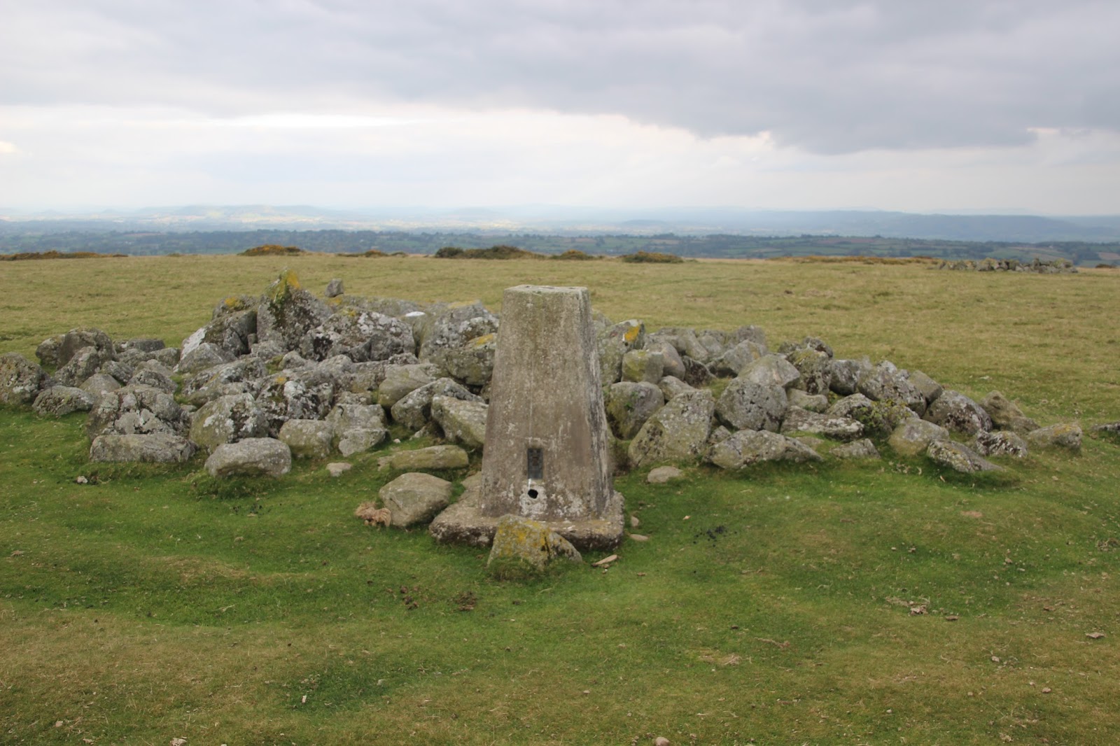 |
| Hergest Ridge trig point
Click on photograph to view slide-show
|
 |
| GPX can be downloaded from www.shareyouradventure.com |
First planned as an 8 mile figure 8 route starting in Kington, following yesterdays late finish on Wapley & Shobdon Hills I had already decided to split the route in to two as a morning and afternoon walk with a spot of lunch in between. It seems however that yesterday took more out of me than I thought as by the time I had got up in the morning, got myself ready and driven to Kington, it was already past 2pm. So much for a morning walk.
So the plan now was to do two up and back walks along the ascent route still based in Kington. I decided to go up Hergest Ridge first for no other reason than it was the furthest but was soon thinking whilst walking along the Offas Dyke path up Ridgebourne Road why I had not driven close to the summit. See cars parked at the end of the road near Haywood Farm convinced me this is what I should have done and decided to drive closer to Bradnor Hill because no matter how tired I felt, there was no way I was not going to get the last Herefordshire hill out of the way on this trip.
As it turned out the walk up the road loosened up my tired legs making the steady ascent up to the high point along Offas Dyke towards Whet Stone most enjoyable. passing some spruce trees and memorial bench to Nan Farrar I came across a circular pond which I used to change course leaving the path and heading for Hergest Ridge summit marked by a large pile of, what I assume, naturally placed stones.
From here it was a quick walk east to the trig point then return back Offas Dyke following contours. Returning to the parked cars I was reminded that this would have been the best place to have parked myself cutting the total walk down by over a mile. On returning to the van I warmed some soup up in the van for a late lunch then drove closer to Bradnor Hill parking near Kington Golf Club.
 |
| Bradnor Hill summit.
Click on photograph to view slide-show
|
|
| GPX can be downloaded from www.shareyouradventure.com |
There is parking in the golf club car park, but thought it best not to assum it was OK and parked on open ground near the car park entrance.
Rather than head straight for the summit past the club house I followed to past the club shop and along the eastern golf course boundary. I stayed on this track as it changed from tarmac to hard core then just a grass track, no doubt used by greenkeepers all the way round to the 7th Tee.
As it was now gone 5pm in October there were not any golfers on the course so it was a matter of walking the length of the 7 fairway then turning right towards the 8th tee where just beyond I found a pile of stones hidden by fern.
After photos and logging I was able to find the most direct path back to the track and return to the clubhouse to complete the final Herefordshire Marilyn.
Bredon Hill
 |
| Bredon Hill viewing stone.
Click on photograph to view slide-show
|
 |
| GPX can be downloaded from www.shareyouradventure.com |
As if bagging 12 Marilyns on this trip instead of the planned five was not enough I managed a final bonus by stopping off in Great Comberton on the way home to pick off this isolated Marilyn.
The quickly hatched plan was a circular (yes I still like to do them if I can) walk through Manor Farm and on to the summit via Stump of Oak. then return from the summits along footpaths to the west then down the north ridge back to Great Comberton.
On top of the hill is Kemerton Camp an Iron Age Fort. More obvious is Banbury Stone Tower built in the 18th century on the inner ramparts.
Heading up hill I was expecting the tower to be the highest point but after following the ramparts round to the tower the highest point is clearly visible about 30m to the north east. Again you are naturally attracted to the viewing stone as the high point but it is in fact about 5m north in some clumps of grass.
Checking the descent route on my smartphone, for the third time this trip, the screen went blank even though the battery indicator said 40% available. Without any other map I had no alternative than to return back along the ascent route which I could remember. Although I will have paper maps for my next Nuttall trip I really must sort out this phone problem to properly log routes walked.