
Walk Summary
Pen Llithrig y Wrach translates to "The Hill of the Slippery Witch". Not so sure about the witch part but it was certainly slippery as the first of the winters snow turned to slush on the descent.
Today's walk will be the last of the planned trip on the day planned to be the last day with all scheduled walks walked as well.
That is bang on schedule.
Because of the excellent weather enjoyed over the last 10 days I only needed 2 rest days and managed a bonus walk (walk of a lifetime) up Tryfan and round The Bochlwyd Horseshoe.
So what's the problem?
Well I am sorely tempted to just jump in the van and drive straight home. The only thing stopping me is today's walk will visit the 23rd and final Nuttall of The Carneddau. Since the trip objective was to complete The Carneddau Nuttalls, even though I have climbed 4 extra in The Glyders the trip in my mind would not be completed successfully unless I went up the final Nuttall.
OK well let's cut it short and not bother with Moel Eilio, after all it is only a Dewey. Well the problem with that it was also on the plan to visit all 7 Dewey's in The Carneddau.
Well maybe I should do the full walk and drive home tomorrow as planned. We'll see after the walk, but having decided to drive home after the walk I can't see me staying on that extra night even if it is on the plan.
I see it is OK to deviate from the plan and go home early if the plan is finished, but it is not OK to deviate from the plan if it is not finished?
That's about the size of it. Plus I really am missing the wife.
Walk Statistics |
| Creigiau Gleision from Pen Llithrig y Wrach |
Today's walk will be the last of the planned trip on the day planned to be the last day with all scheduled walks walked as well.
That is bang on schedule.
Because of the excellent weather enjoyed over the last 10 days I only needed 2 rest days and managed a bonus walk (walk of a lifetime) up Tryfan and round The Bochlwyd Horseshoe.
So what's the problem?
Well I am sorely tempted to just jump in the van and drive straight home. The only thing stopping me is today's walk will visit the 23rd and final Nuttall of The Carneddau. Since the trip objective was to complete The Carneddau Nuttalls, even though I have climbed 4 extra in The Glyders the trip in my mind would not be completed successfully unless I went up the final Nuttall.
OK well let's cut it short and not bother with Moel Eilio, after all it is only a Dewey. Well the problem with that it was also on the plan to visit all 7 Dewey's in The Carneddau.
Well maybe I should do the full walk and drive home tomorrow as planned. We'll see after the walk, but having decided to drive home after the walk I can't see me staying on that extra night even if it is on the plan.
I see it is OK to deviate from the plan and go home early if the plan is finished, but it is not OK to deviate from the plan if it is not finished?
That's about the size of it. Plus I really am missing the wife.
Walk Date - 06 December 2014
Walkers - Steve Smith
Accommodation - Betws-y-Coed Youth Hostel
Start Point - End of road through gate at Brynog Uchaf (GR - SH 74405 64186)
Start Time - 10:17
Finish Point - End of road through gate at Brynog Uchaf (GR - SH 74405 64186)
Finish Time - 15:18
Duration - 5hrs 01mins
Average pace - 1.81mph
Distance Walked - 9.08 miles
Height Ascended - 704.43metres
Other walks on this trip
2014
November
27th Creigiau Gleision & Craiglwyn
28th Carnedd Dafydd, Pen yr Ole Wen & Foel Meirich
29th Carnedd Llewelyn, Yr Elen & Pen yr Helgi Du
December
01st Dulyn Reservoir round + Llwytmor
02nd Beras Bach & Mawr +Drosgl & Gyrn Wigau
03rd The Bochlwyd Horseshoe
05th Drum, Pen y Castell & Carnedd y Ddelw + Tal y Fan
06th Pen Llithrig y Wrach
Nuttalls (190W - 444E&W)
Pen Llithrig y Wrach (64W - 317E &W)
Hewitts (138W - 317E)
Pen Llithrig y Wrach (46W - 2225E, &W)
Marilyns (158W - 1550E,W&S)
Pen Llithrig y Wrach (19W - 112E,W&S)
Deweys (241W - 427EW&S)
Moel Eilio (21W - 68E &W)
HuMPs (364W - 2977EW&S)
Pen Llithrig y Wrach (27W - 175E,W&S)
W: Wales.
E,W&S:England,Wales & ScotlandRoute
Moel Eilio

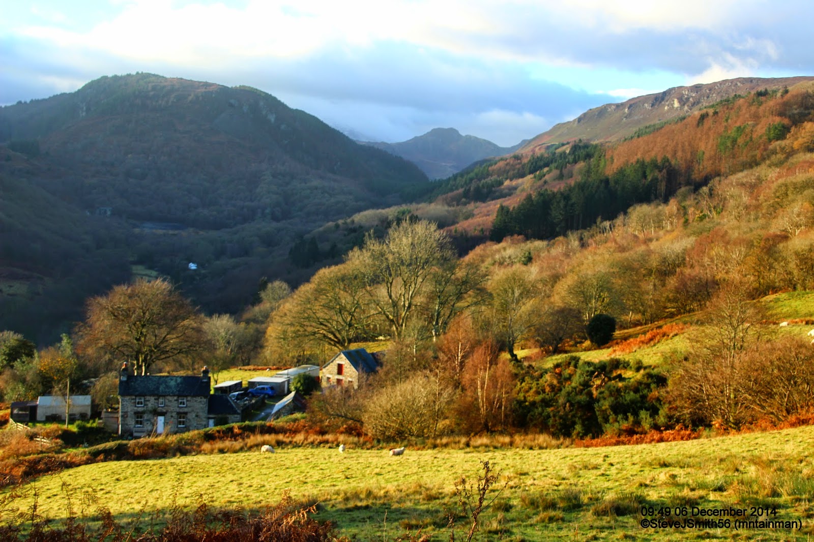 |
| Had to stop on way to walk start to photograph this lovely view. (See more photo section for location) |
Cross the second wall and pick up the path which now seems a little better defined until you come to the third wall.
Do not expect too much of the wall as it is derelict but there is a reasonable path to follow east along the top and sometimes to the left of it. Tempting enough to follow anyway, away from the main summit of the day Pen Llithrig y Wrach, and not miss out the Dewey Moel Eilio.
 |
| Rudimentary step giving access over fence to summit area on east side of Moel Eilio |
Pen Llithrig y Wrach
 |
| Left to right. Pen Llithrig y Wrach, Pen yr Helgi Du & Carnedd Llewelyn from Moel Eilio |
 |
| On way to Craig Ffynnon. Ladder stile - confirmation of PROW. It may be on the map, but not too evident on the ground |
Well that led to even thicker heather and rougher ground heading once again up hill on an even steeper gradient. At least keeping the fence in view to my right ensured I would eventually reach the summit area.
 |
| Well defined path from Craig Ffynnon more or less all the way up NE ridge of Pen Llithrig y Wrach |
After all the heather surfing of the day so far, the path was a welcome relief not to mention shade from the blustery cold wind. First time out of the wind was prompt enough for me to find a large rock from the old wall the path followed and get out my flask and sandwiches.
Suitably refuelled after lunch it took just 45 minutes to cover nearly 1 mile and 200m of ascent to the summit of Pen Llithrig y Wrach. I ended up walking through my first snow of the winter. Nothing much but enough to live up to the translation of the hills Welsh name.
 |
| Towards Capel Curig. A bit of snow on descent down Pen Llithrig y Wrach, more slippery than anything. |
The snow made the path quite slippery and as the snow melted lower down made parts of the path muddy in places. Because of the steep descent in places the mud was replaced by rocky steps and craggy ground but the path was well defined all the way dissuading me from cutting off left early to make a steeper descent on or over Carreg-ar-y-rhos, staying with the path all the way down to the bottom and the bridge over the feeder stream to Llyn Cowlyd Reservoir.
 |
| Bridge over feeder stream to reservoir where we turn left without crossing. Crimpiau beyond |
Close to the dam, the path turns in to a track and from here on it is a simple case of following the track round the dam to the middle and following it along the pipeline until it veers away from the pipe and continues to walks end and the dam.
Over all a satisfying walk not least because it successfully completed the plan I had made before setting off on the trip.
At 15:30 it was still daylight so after a change of clothes and a 2nd lunch I set off home for Suffolk. With diversions and fatigue I arrived home 01:30am. At the time the drive seemed harder than any of the walks.
More Photographs
 |
Pen yr Helgi Du & Carnedd Llewelyn seperated by Bwlch Eryl Farchog, from Pen Llithrig y Wrach
Click on photograph to view slide-show
|