
Walk Statistics
Walk Date - 08 April 2014
Walkers - Steve Smith, Gina Smith
Accommodation - Pilgrims Way Caravan and Camping Park, Fishtoft, Boston
Start Point - South side of Surfleet Seas End sluice (TF 27996 29250)
Start Time - 14:14
Finish Point - South side of Surfleet Seas End sluice (TF 27996 29250)
Finish Time - 16:12
Duration - 1hr 58mins
Average pace - 1.73mph
Distance Walked - 3.41miles
Height Ascended - 29.95metres
Peaks visited
Historic County Tops(49E - 63E&W - 94E,W&S)
Pinchbeck Marsh (23E - 27E &W -28E,W&S)
E: England
 Walk Summary
More Photographs
Walk Date - 08 April 2014
Walkers - Steve Smith, Gina Smith
Accommodation - Pilgrims Way Caravan and Camping Park, Fishtoft, Boston
Start Point - South side of Surfleet Seas End sluice (TF 27996 29250)
Start Time - 14:14
Finish Point - South side of Surfleet Seas End sluice (TF 27996 29250)
Finish Time - 16:12
Duration - 1hr 58mins
Average pace - 1.73mph
Distance Walked - 3.41miles
Height Ascended - 29.95metres
Peaks visited
Historic County Tops(49E - 63E&W - 94E,W&S)
Pinchbeck Marsh (23E - 27E &W -28E,W&S)
E: England
E&W: England & Wales
E,W&S:England,Wales & Scotland
RouteE,W&S:England,Wales & Scotland

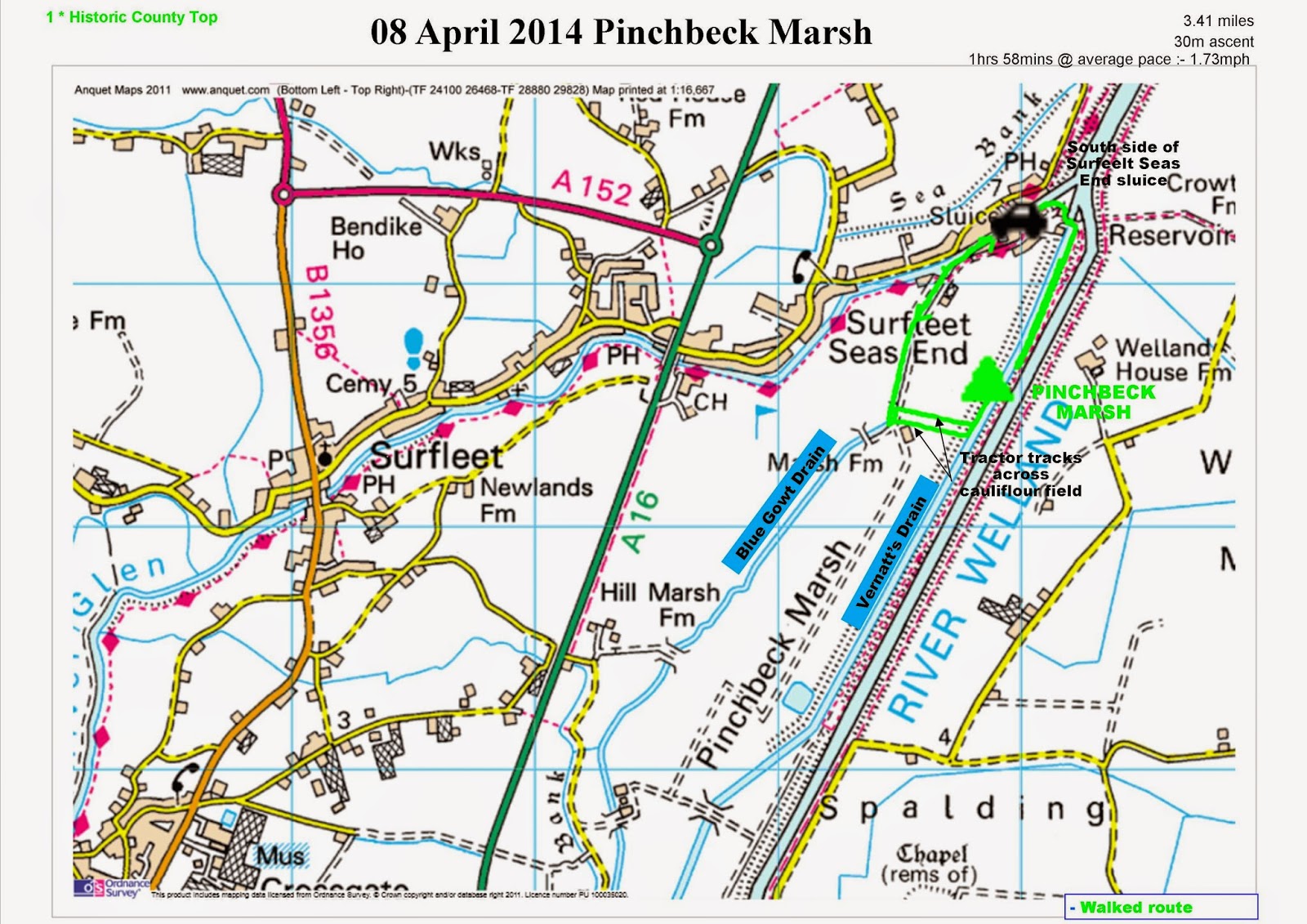
Pinchbeck Marsh may be the lowest high point in the UK but was certainly one of the most difficult in terms of access. The summit such as it is is situated on the west bank of Vernatt's Drain about 600m from the sluice separating it from the tidal River Welland.
With only an OS 1:50000 Landranger map available I had planned to access the west bank from the sluice, however there was a very clear sign indicating it was "Private Property" and "Keep Out" so just in case an alternative access was not available we walked along the east bank as far as Welland House Farm and observed it across the river.
Returning to the van at Surfleet Seas End sluice Gina set off along the freshwater side of the River Glen attracted by the beautiful views. As we reached the bridge over Blue Gowt Drain near the golf course we followed the drain south along a farm track as far as the disused derelict corrugated iron barn on Marsh Farm.
This provided an excellent view of the summit but tantalisingly blocked by a cauliflower field. I was itching to cross the field but Gina was not keen "What's the point..." she exclaimed "...you can see it from here. Well that is like arriving in Wasdale Head and not going up Scafell.
As the field had had the first crop harvested and there were clear tractor tracks to follow I quickly ran the 250m across the field to the bank then turned left northwards to the slight elevation in the sea of flatness that was the summit. On arrival there were a couple of candidates for the summit, both of which had to be walked over and photographed. The high point may well have been in the middle of a massive bramble bush but no way was I going to stand in the middle of that.
Returning south along the bank another candidate for a high point could be seen about 500m ahead, but I think I would have been pushing my luck if I had insisted on visiting that as well. So I put my trust in the DoBIH but in an area devoid of a single contour would be interested to know how this point was chosen.
On return to the River Glen we could have found our way back to the van along the road where I believe there could also be an alternative access to the bank by following the field boundary around to Vernatt's Drain just south of the property blocking access near Vernatt's bridge. But we returned along the river bank and were pleased we did, the sun was peeping out and disappearing behind clumps of cumulus and cumulonimbus giving excellent light for photographs.
As with many of my walks I can think of an excuse to return and if we do, will definitely make it a longer walk along the River Glen to Surfleet (it really is beautiful) and then on to Pinchbeck also along the river. Will decide on the return route if and when we return.
 |
| Riverside residences on River Glen at Surfleet Seas End Photographs to follow |