Shining Tor (96E - 98E,W&S)
E: England
E&W:England & Wales
E,W&S:England,Wales & Scotland
Route
Walk Summary
Having been prompted to write this up in November 2013, following our return from Castleton in our new camper van, some 13 months after actually completing the walk, the perspective now whilst writing is somewhat different to the perspective I had when setting out from the Cat and Fiddle pub back in October 2012.
Back then this was my first walk in the hills since recovering from the SAH I had back in August 2012.
During the intervening months I have made a full recovery, completed the English Nuttalls, climbed our first Corbett (Am Bàthach) with Gina in winter conditions, started the Scottish Munros (completing 12) with my friend John Parkin, continued the Nuttall theme in Wales on my own and finally walked The Great Glen Way in October 2013 with Gina and our friend Joss.
The prognosis was for a full recovery within 3 to 6 months. But what constitutes a full recovery?
"Yes" was the answer to my question
"Run a marathon?"
"Brilliant." I thought - I could not do that before the hemorrhage!
Anyway for me getting out in the hills on my own in winter conditions would be enough.
So to be out after just 2 months was something of a bonus.
The other bonus was being joined by Gina. She had said "There will be no going off in the hills on your own now you know." So with that restriction the only option was for her to supervise me every step of the way.
There was some apprehension on my part, would I be able to cope with the weather and conditions. Would my head explode if I over exerted myself? There was not anything like winter conditions, but there was a threat of showers and there was already a cold wind. Also even though it was only mid October as always, I still felt I had to be prepared for a change in the weather which can descend in this part of the world at anytime.
From Gina's point of view, I have since found out she does not like cold windy conditions (discovered on Am Bàthach) but it also turns out she does not like the uphill part of hill walking along with the sense of foreboding that descends whenever we go out of sight of civilisation or off main paths.
What can I do to assure her that we are prepared enough and everything will be all OK?
Once we are on the summit ridge and it is not too windy everything is fine and no matter how far it is or how steep the descent she copes as well as anybody I know. So what is the psychology at play here that deters her from coming out, but once out (or more correctly on the way down) she enjoys and afterwards looks back on the achievements with pride.
Anyway the weather did not turn for the worse, my head did not explode and the up-hill part of the walk was only 50m higher than the walk start point at England's second highest pub to the walk high point on Shining Tor, some 1½
miles away from the start point. So the worst part for Gina was minimal, we enjoyed excellent views on a clear day considering it was cloudy and we discovered things like the shrine and Erwood Hall that we did not expect. All this combined with the beautiful scenery and the sense of achievement in completing the walk reminded us what hill walking is all about.
Walk Description
 |
| Start at the Cat & Fiddle pub on the A537, Macclesfield to Buxton road |
1.) After coffee and checking with the landlord if it was OK to park in the pub car park we left the
Cat & Fiddle pub and set off along the A537 towards Macclesfield.
 |
| Then take track onto open access land just past radio mast |
2.) As we passed the radio mast on our right we took the first path forking to the right on to open access land.
 |
| Shining Tor beyond High Peak Tea Shop |
3.) With High Peak Tea Shop straight ahead take first turn right up a slight gradient, keeping the tea shop on your left below.
 |
| Shining Tor beyond Stake Farm |
4.) As you reach the top of the hill you will then pass Stake Farm below and to the left.
 |
| Ignore path to right and go through gate on right |
5.) Continue straight ahead ignoring signpost to Goytsclough Quarry and stay on path to take you through first gate on the right.
 |
| Ahead on path then left at wall |
6.) Turn left after gate and continue along path with wall on your left.
 |
| Shining Tor summit area |
7.) Turn left at second wall and follow path with wall on left all way to Shining Tor summit area.
 |
| Shutlingsloe on the left |
8.) Look out for distinctive Shutlingsloe summit also on your left.
 |
| Shining Tor trig point |
9.) The high point is a mound on the east side of the wall, but as the wall probably marks the county boundary the administrative county top for Cheshire is the trig point through the gate on the west side of the wall
 |
| Keep wall on your left and head north to next peak of Cats Tor |
10.) Stay on the east side of the wall and head north for the next summit Cat's Tor.
 |
| Erwood Reservoir to the East from Shining Tor - Cats Tor col |
11.) Cat's Tor summit will be ahead and to you left until you reach the col between Shining & Cat's Tor at which point the path (and wall) veer to the left and head straight up to the summit area.
 |
| Approaching Cats Tor summit area along the east side of the wall |
12.) The cairn is on the other side (west side) of the wall so keep eyes peeled for small cairn otherwise you may walk straight past it.
 |
| Looking back at Cats Tor cairn and of course Shutlinsloe beyond |
13.) Cat's Tor is the last summit of the day so you can either turn round and trace your steps back to the Cat & Fiddle OR as we did continue straight on towards
Pym Chair, then loop back either along or below Foxlow Edge and on to Erwood Hall.
 |
| Path to Pym Chair |
14.) We chose to cut the corner off before Pym Chair ending up in boggy ground at bottom of Withinleach Moor.
In retrospect it would have been better to stay on the path along the top of Oldgate Nick then turn left after Pym Chair along The Street.
 |
| We turned off early to cut off Pym Chair corner across Withinleach Moor |
15.) Where ever you join the street. look out for the foot path to the right mid way between the 438 and 417 spot heights.
 |
| Gateway to path below Foxlow Edged to Erwood |
16.) From here you have the choice to take the high path or the low path.
 |
| Whats that down there? |
17.) We took the low path and were rewarded with the discovery of a shrine (
listed on English Heriage website) said to have been erected in memory of a Spanish aristocrat and governess at
Erwood Hall,
Miss Dona Maria Dolores de Ybarguen.
 |
| Path towards Erwood Hall and Shooter's Clough |
18.) After visiting the shrine continue south along a pretty valley flanked by Foxlow Edge on the left and a plantation on the right which extends all the way to Shooter's Clough and
Erwood Hall beyond.
 |
Descending to the stream.
But don't go over this bridge, continue straight on towards camera |
19.) When you reach a seat and after maybe stopping for a rest, descend to the stream which eventually flows in to Shooters Clough and keep left - ignoring the first bridge on your right
 |
| Go across bridge over stream to north of Erwood Hall |
20.) Cross stream over long bridge/walkway and start fairly steep ascent up stepped pathway to
Erwood Hall.
 |
| Erwood Hall |
21.) Once all photos have been taken continue following path around ruins and through what were the gardens until the path joins another path.
22.) At the fork take a sharp left, descending for a short while then an to a wooded path.
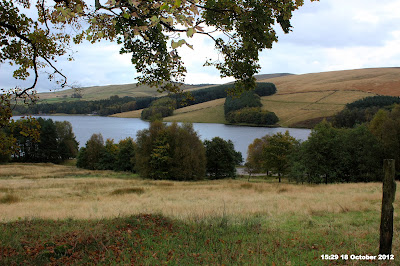 |
| Erwood Reservoir |
23.) Eventually you will come to a clearing and see Erwood Reservoir on your left.
 |
| Follow sign and path to Goytsclough Quarry |
24.) Very soon you reach a cross roads in the path with a signpost. Follow sign to Goytsclough Quarry and join the public road.
25.) It is now public road all the way back to The Cat & Fiddle and walks end but that is 2½ miles away.
 |
| Lunch stop, sheltering from rain at Goytsclough Quarry |
26.) First we stopped for lunch at Goytsclough Quarry where we had lunch and was able to shelter from rain which had just started.
 |
| Old bridge to nowhere near Goytsclough Quarry |
27.) After lunch and near the quarry we passed what looked like a bridge to nowhere but in fact I think it is the
Old Packhorse bridge that was moved when Erwood reservoir was built.
28.) Stay on the road along the Goyt valley, crossing Derbyshire Bridge, until a junction with public conveniences on the left.
 |
| First sight of aerial and more importantly Cat & Fiddle pub about 1 mile away |
29.) By now the rain which started at lunch had really set in, so from here it was a case of turning right at the toilets, getting our heads down and following the road until it joins the A537.
30.) The walk is never over until it is over but on joining the A537 all that remains is to remember your road safety and stay on the footpath at the side of the road the short distance to
The Cat & Fiddle pub walks end and destination for tonight's meal and well earned pint.
More Photographs
Shining Tor trig point and Shutlingsloe
| Click on photograph to view slide-show |

 Walk Summary


